
WHEN: Sept. 30 to Dec. 11, 2010
Mention London and medievalism in the same sentence and people naturally think of England. But it is the eponymous city in Southwestern Ontario that is the focus of this series of exhibitions and related programs. It really should come as no surprise that London, Ontario is replete with medieval features. Life in early 19th century rural Britain had remained essentially the same for centuries and many settlers were determined to replicate their homeland. The early 19th century was also a period of gothic revivals in literature and architecture.So it is understandable that much of what constitutes the region’s history parallels the development of Northern Europe a 1000 years before.
What is surprising is that this continuity of medieval thought and values has not been examined seriously before Professor Kathy Brush of the Visual Arts Department at Western began her research for Mapping Medievalism at the Canadian Frontier. Assisted by graduate students, Dr. Brush explores the “Canadian frontier” as a source of myths and histories that stimulated multiple discourses—visual and textual —on both sides of the Atlantic well into the 20th century.
By interpreting Ontario’s history and visual culture through the lens of medievalism the project charts the diverse cultural forms interpreted by colonists who transformed the deep forests into landscapes punctuated by castles and neo-Gothic buildings. The project also examines the rich First Nations’ cultures that flourished in the Great Lakes region during the period roughly contemporary with the European Middle Ages.
Mapping Medievalism at the McIntosh Gallery includes historical maps, Native artifacts and early paintings and watercolours of the region. Its scope is extended through the complementary exhibition Mapping Iroquoia: Shelley Niro and Jeff Thomas, which provides audiences with a contemporary First Nations’ perspective on the complex issues raised by the topic. Concurrent exhibitions at Western’s D. B. Weldon Library and Museum London, which includes important medieval art from the University of Toronto Art Centre’s Malcove Collection, round out this ambitious project. A book is forthcoming.
Mapping Medievalism at the Canadian Frontier received funding from the London Heritage Council through its Community Heritage Investment Program, the Department of Visual Arts’ Cohen Explorations Program, and the Social Sciences and Humanities Research Council of Canada. The McIntosh Gallery acknowledges the support of the Canada Council for the Arts, the Ontario Arts Council, Western University, Foundation Western, The Ontario Arts Foundation, and its members and donors.
WHEN: Sept. 30 to Dec. 11, 2010
Opening reception: Sept. 30 at 8:00 PM
While medieval Europe was undergoing dramatic religious and social upheaval culminating in the crusades during the late eleventh century, the Indigenous people of North American were also experiencing profound changes to their way of life with the arrival of corn-based agriculture. Gradually less reliant on hunting, corn cultivation afforded them more time to develop sophisticated forms of social organization including rituals, ceremonies, architecture and the arts.
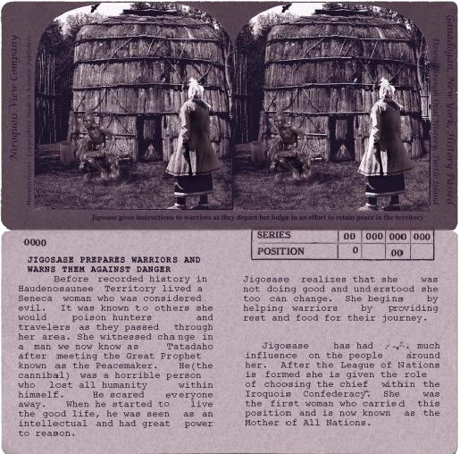
Great societies arose in eleventh century North America, an era that archaeologists, who discovered their remains in earth mounds, named the Mississippian period. In present day New York State, a leader known as the Peacemaker, a Seneca woman named Jigosase, and an Onondaga man named Hiawatha, established the Haudenosaunee (Iroquois) Confederacy, the world’s oldest continuous democracy. This profound historical achievement continues to influence contemporary Iroquoia as well as other democratic nations.
Mapping Iroquoia brings together Shelley Niro and Jeff Thomas who, through their art practices, build upon the Haudenosaunee Confederacy’s enduring legacy. Curated by Jeff Thomas, Mapping Iroquoia has been organized by the McIntosh Gallery in response to the concurrent exhibition Mapping Medievalism at the Canadian Frontier. These complementary projects challenge conventional historical narratives by examining the way in which cultures interact over time in unexpected and productive ways through dialogue and exchange.